ruby.social is one of the many independent Mastodon servers you can use to participate in the fediverse.
If you are interested in the Ruby programming language, come join us! Tell us about yourself when signing up. If you just want to join Mastodon, another server will be a better place for you.

Administered by:

Server stats:

1.1K
active users

#flooding

38 posts27 participants1 post today

Who monitors coal ash pits, dams and floodwater at former coal plants? The owner

This weighs heavy on my mind today because a few miles upstream of my rural Ohio village on the #OhioRiver, with 7-blocks of its 9-blocks under water and river flooded, is a decommissioned coal plant. The largest coal ash pit at the site is 163 acres, more than 2 miles long if you walk all the way around to where you started at. #Flooding #Ohio #Coal #environment

wcpo.com/news/local-news/i-tea

The coal ash pits at the former Beckjord coal plant site along the Ohio River on April 7, 2025, during flooding.
WCPO 9 Cincinnati · Who monitors coal ash pits, dams and floodwater at former Beckjord Coal plant? The ownerBy Paula Christian

Tomorrow from 1-2pm EDT CIRCA is hosting a webinar about 2 case studies from the Resilient Connecticut project. Communities across Connecticut are facing uncertainty when it comes to understanding and managing current and future flood risks. Join us for a webinar highlighting two case study projects currently underway in East Haddam and Stonington Mystic, CT as part of the Resilient Connecticut planning and technical assistance program.
Register here: events.teams.microsoft.com/eve

Significant, generational and historic #flooding across the Ohio River Valley following multiple days of heavy rainfall and severe storms. You can see the extent of the flooding in the Sentinel-1 #SAR derived flood mapping I made in support of operations here. I have masked out normal water detection from previous Sentinel-1 images so I'm only highlighting the floods. Sentinel-1 Acquisition Relative Orbit 121 on 6 Apr 2025 @ 23Z nohrsc.noaa.gov/special/leafle

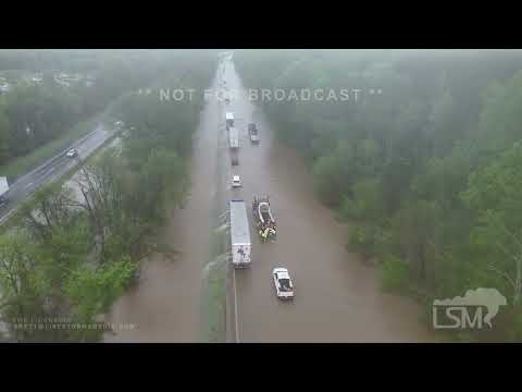
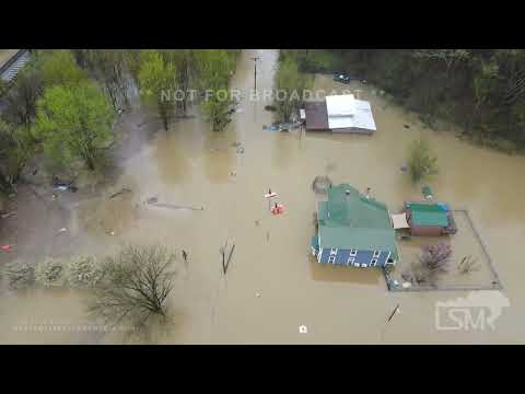
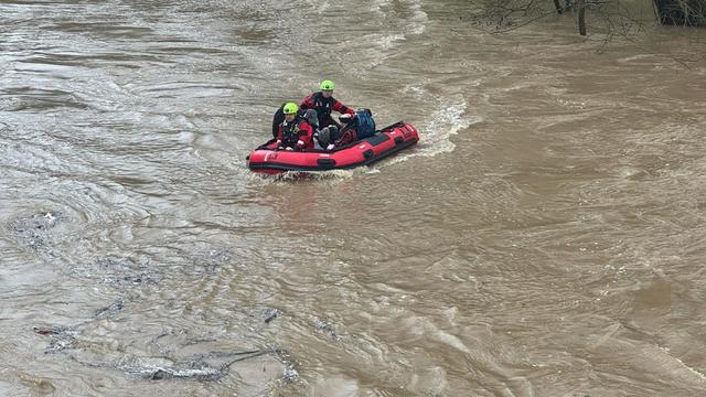
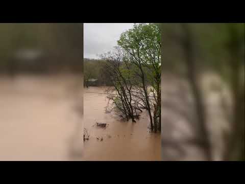
SOB! So, our weather is messed up. Not only are 7 of my 9-block village under water and mud from historic Ohio River flooding but NOW we are under a freeze watch for sub-freezing temperatures.

...FREEZE WATCH IN EFFECT FROM LATE MONDAY NIGHT THROUGH TUESDAY
MORNING...

* WHAT...Sub-freezing temperatures are forecast in the lower and
middle 20s.

* WHERE...Portions of east central and southeast Indiana, northeast
and northern Kentucky, and central, south central, southwest, and
west central #Ohio

* WHEN...From late Monday night through Tuesday morning.

* IMPACTS...Frost and freeze conditions could kill crops, other
sensitive vegetation and possibly damage unprotected outdoor
plumbing.

#Weather#WX#OHWX

Various rivers are forecast to set new records for water height during the ongoing flooding.

Colored dots on the map are streamgages.
Red = moderate flood
Purple = major flood

For a near real time graph, click/tap a dot and follow the link.

To search for a town or address click/tap Menu > Search.
#SevereWx #Flood #Flooding

Open GISsurfer map:
mappingsupport.com/p2/gissurfe

Replied in thread

@Lizette603_23 We're safe. The first 7 of my 9-block village on the Ohio River will be completely under water with significant flooding, probably before the day is over. Many blocks already are. We are on the first ridge, just above it. It would take 40 or more feet above flood stage to reach us. #OhioRiver #Flooding #Ohio

My village has no levy or flood protection.

Homeless woman, who took shelter from Ohio River flooding in Cincinnati by going on the center stage of P&G Pavilion to higher ground, rescued by fire department.

The Ohio River is nearing historic flooding levels.

#OhioRiver #Flooding #Ohio

🔗 wcpo.com/news/local-news/hamil

#Cincinnati officials are warning of historic flooding. 'It's gonna flood in areas that typically don't' said Cincinnati Assistant Fire Chief Matt Flagle

The river is going to crest by the end of the weekend, well over 60 feet, which is eight feet above flood stage

wcpo.com/news/local-news/hamil

Sawyer Point Water Rescue 4/6/25
WCPO 9 Cincinnati · CFD: Woman taking shelter at Sawyer Point stage rescued from Ohio River floodingBy Molly Schramm

AP: Flooding in southeastern Oregon prompts evacuation orders, school closures and health concerns

"BURNS, Ore. — Flooding in rural southeastern Oregon from what authorities have described as “historic levels” of snowmelt and rainfall has prompted evacuation orders, school closures and public health concerns, submerging roads and agricultural land and damaging homes and businesses...."

latimes.com/world-nation/story

This photo provided by the Deschutes County Sheriff's Office in Oregon shows its water rescue team as it helps respond to flooding in neighboring Harney County in March 2025. (Deschutes County Sheriff's Office via AP)
Los Angeles Times · Flooding in southeastern Oregon prompts evacuation orders, school closures and health concernsThe Harney County Sheriff's Office said more than 1,200 people were under the highest level of evacuation orders.

Colored dots on the map are streamgages.
Red = moderate flood
Purple = major flood

For a near real time graph, click/tap a dot and follow the link.

The are *many* more streamgages that the map can display. A lot of them will show a graph of water level but do not have defined levels for “moderate” and “major" flood. If you need help turning on that overlay layer, please read the “Map tips”. That link is in the upper left corner of the map.
#SevereWx #Flood #Flooding

Open GISsurfer map:
mappingsupport.com/p2/gissurfe